
Soil
Geology and Soil
The topography of Orange County is generally subdued with low, north-south ridges and valleys that make up most of the county. The terrain on the western side of the county is somewhat steeper as it nears the foothills of the Green Mountains, compared to the more rolling topography closer to the Connecticut River. The highest elevation is Butterfield Mountain in the Town of Orange at 3,166 ft, down to the lowest elevation along the Connecticut River at 400 ft. The bedrock underlying the western part of the county is mainly quartz mica schist, interbedded phyllites (metamorphic slate), slates, quartzites, and limestone. The eastern part of the county is underlain by somewhat lower metamorphic grade rocks consisting of phyllites, slates and some schist and quartzite. When the last glacier retreated 13,000 years ago the river valleys were deepened and widened and received glacial fluvial and glaciolacustrine deposits. Glacial till makes up approximately 92% of the county.
The 1978 Soil Survey of Orange County produced by the USDA-NRCS provided a graphic illustration of the general location of major soil types found in the area:
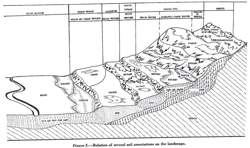
The rich sediments deposited after glaciation and alluvial sedimentation have created river valleys with rich soil better suited for agriculture than the steep hillsides. Because most of the river valleys throughout the basin are narrow, much development and agriculture are located along the rivers where soil is rich and deep, and the topography is flatter. Typical prime agricultural soils found on lower slopes include: Agawam, Belgrade, Buckland, Cabot, Charles silt loam, Colrain, Hadley, Hartland, Merrimac, Ninigret, Pomfret, Stowe, Tunbridge-Woodstock, Vershire-Glover, Walpole, Windsor, and Winooski.
In general, Windsor County consists of high ridges running north south and cut at intervals by the major rivers. The Connecticut River is about 350 ft above sea level, the adjacent hills range from 900-1200 ft, increasing on the western side of the county to 2500-3000 feet. Mount Ascutney is an isolated peak of igneous rock in the east central part of the county with an elevation of 3165 ft. Most of the soils in the county are of glacial origin. Glacial till is found in the uplands, is relatively thin, and typified by the Hollis series. Deeper deposits occur at the base of the slopes. Where granite, gneiss, or other crystalline rock occur, the surface is rough and the land is generally most suitable for forestry or pasture. The soils formed in schist tend to be smoother but hilly and suitable for pasture with some gentle slopes suitable for cultivated crops. The terrace materials are alluvial deposits typical of the Hinckley and Merrimac series. Podunk is found in the low lying areas along the waterways.
Typical prime agricultural soils in Windsor County include: Adams, Agawam, Belgrade, Buckland,Cabot, Colton, Croghan, Dummerston, Eldridge, Fullam, Grange, Hadley, Hinckley, Hitchcock, Limerick, Marlow, Monadnock, Nicholville-Adams, Ninigret, Ondawa, Peru, Skerry, and Colonel, Podunk, Raynham, Rumney, Shelburne, Teago-Pomfret, Tunbridge- Lyman, Vershire Buckland complex, Vershire Dummerston complex, Windsor, and Winooski.
Soil carbon is the foundation of soil health, which can enhance climate resilience, water quality, and farm productivity. The promise of these co-benefits may balance some of the uncertainty in long term carbon sequestration. These are important environmental priorities that align reducing agricultural vulnerability with meeting environmental targets. In 2022, UVM reported that Northeastern soils and climate are naturally conducive to high levels of soil carbon. When compared regionally and nationally, Vermont’s agricultural soil carbon levels are high. An average of 86 MT carbon per hectare and 4.3% organic matter was observed. Finely textured soils of glacial origin have a high affinity for holding carbon, and the cold temperate climate of the northeast prevents losses. Together, these conditions contribute to our region having higher soil carbon stocks than the national average. It may be possible to increase soil carbon on Vermont farms which can complement other strategies to reduce concentrations of atmospheric greenhouse gasses.
Soil carbon stocks are improved through changes in soil organic matter. Organic matter is the living or formerly living portion of the soil. It is a reservoir of organic carbon, biological activity, and nutrients; and is foundational to many ecosystem services and soil functions. This pool of organic carbon is influenced by soil texture but can be improved by management strategies that limit soil disturbance and increase inputs of biological carbon such as cover crops, crop residues, manure or other forms of organic carbon. Soil carbon sequestration in agricultural soils is a long-term endeavor that can take 5 to 7 years to show up in a routine soil test and can easily be lost to increases in tillage or changes in management. Evidence that recommended practices lead to additional soil carbon in this climate on Vermont soils is an important underpinning for conservation programs and policy. There is evidence that additional soil carbon sequestration may be achieved through the adoption of recommended practices that reduce tillage and increase organic matter inputs through residues, compost, and manures.
From
Soil Survey of Orange County Vermont USDA, SCS 1978
Soil Survey of Windsor County Vermont, USDA, SCS 1918
Soil carbon storage and sequestration in Vermont agriculture Alissa White, Heather Darby & Donald Ross. Research Brief, April 2022. University of Vermont Extension, Gund Institute for Environment, and Department of Plant & Soil Science