
Basin 9: White River (2018)
The White River Basin encompasses 710 square miles in Vermont, draining portions of Addison, Orange, Rutland, Washington and Windsor Counties. The basin covers significant portions of 20 individual towns. The White River mainstem is approximately 56 miles long and is the longest free flowing large river in Vermont and the longest undammed tributary to the Connecticut River. An emerging network of designated recreational access sites, the White River Water Trail, showcases the basin’s overall good water quality and provides opportunities for water-based recreation such as fishing, swimming, boating, and related recreational uses. The mainstem of the White River is recommended as an Outstanding Resource Water for recreation. 42 waters have been identified for protection. In 2016, five waters were protected at the highest classification level.
Geologically, the watershed is sliced in half by the geological formation known as the Richardson Memorial Contact, which runs north to south, roughly from the eastern edge of Roxbury to central Barnard. This contact point separates the post-Taconian carbonate rich rocks to the east from the older quartz-rich rocks to the west. This split in bedrock is relevant as it represents an underlying structure that affects the chemistry of ground and surface waters. The younger rocks to the east are less tightly formed and more porous than those of the west, therefore allowing water to penetrate more quickly, which recharges groundwater at higher rates than the west. Waters east of the split also have a greater buffering capacity, mitigating impacts from acid rain. Geologic resources along the contact in Basin 9 include chromium, iron, arsenic, copper, zinc, and lead. To the east, quarried resources include white granite in Bethel, and talc, soapstone, serpentinite, and verde antique.
The rich sediments deposited by Lake Hitchcock after glaciation and alluvial sedimentation from historic flooding have created river valleys with rich soil better suited for agriculture than the steep hillsides. Because most of the river valleys throughout the basin are narrow, much development and agriculture are located along the rivers where soil is rich and deep, and the topography is flat. Unfortunately, this land use pattern also leads to surface water pollution from stormwater runoff and inherently higher flood damage risks from encroachment into the river corridors and floodplains.
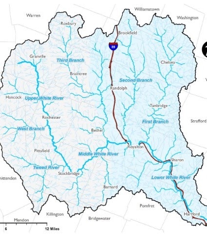
The basin can be divided into five major sub-basins – the First Branch, Second Branch, Third Branch, Upper White, and Lower White.
Overall, land use in the White River basin is 1.3% open water and wetlands, 4.6% developed (including the interstate and roads), 8.4% agriculture, and 82.7% forests. The forested landscape is largely responsible for the good water quality in the basin. Many of the areas in the White River basin that are experiencing degraded water quality trends are adjacent to dense road and residential development (Jericho Brook, Third Branch, Ayers Brook, Sunset Lake, and Silver Lake) and agricultural lands (Kingsbury Brook, Second Branch, and First Branch). Managing land use to reduce discharge of polluted runoff and allowing adequate space for treatment can both improve and protect water quality.
A Total Maximum Daily Load or TMDL is the calculated maximum amount of a pollutant that a waterbody can receive and still meet Vermont Water Quality Standards. In a broader sense, a TMDL is a plan that identifies the pollutant reductions a waterbody needs to meet Vermont's Water Quality Standards and develops a means to implement those reductions. TMDLs can be calculated for reducing water pollution from specific point source discharges or for an entire watershed to determine the location and amount of needed pollution reductions.
TMDLs for Basin 9 include:
- 2004 TMDL for 7 Acid Impaired Lakes in Vermont
- Vermont Statewide Total Maximum Daily Load (TMDL) for Bacteria-Impaired Waters
- Long Island Sound (LIS) Dissolved Oxygen TMDL
- Northeast Regional Mercury Total Maximum Daily Load