
Water
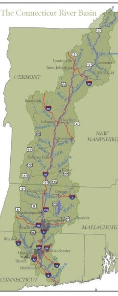
Both the WRNRCD and the ONRCD are bound to the east by the Connecticut River making both Districts part of the Connecticut River Watershed. The Connecticut River Watershed is the largest river ecosystem in New England, encompassing approximately 11,000 square miles and spanning four New England states. The Connecticut River was designated as a National Heritage River in 1998, and it is now a national blueway and priority landscape of national significance for the America’s Great Outdoors Initiative. This is one of the most at-risk areas of New England for forest fragmentation. This is an area with multiple federal and state interests, with public land acquisition, access to recreation, and economic interests leading the way. (ctriver.org)
Every watershed can be subdivided into smaller and smaller watersheds down to an individual stream. The watersheds within Vermont are covered by a Tactical Basin Plan (TBP). For WRNRCD and ORNRCD the relevant Tactical Basin Plans include: Basin 9 White River, Basin 14 Stevens, Wells, Waits, and Ompompanoosuc Rivers, and five Connecticut River tributaries, and Basin 10 Ottauquechee River & Black River and six Connecticut River tributaries. All of these waters drain into the Connecticut River.
To help protect Vermont’s clean water, every five years the Vermont Department of Environmental Conservation’s (VTDEC) initiates the tactical basin planning process. Tactical Basin planning is designed to identify and prioritize state and local water quality issues and implement on-the-ground watershed protection and restoration projects. The following sections highlight some of the key findings from each TBP and the projects that often guide much of the District’s work plan. Please refer to the Vermont DEC page linked at the heading of each plan for more information on each of the Basins.